CHICAGOLAND — Sunday is shaping up to be one of the hottest days in about a week across Chicagoland, with highs reaching the mid to upper 80s this afternoon. The sun is expected to return, at least in a scattered fashion, as clouds continue to linger through the day. A front will bring drier air into the region by tonight, and a noticeable drop in dew points should make conditions feel more comfortable heading into tomorrow.
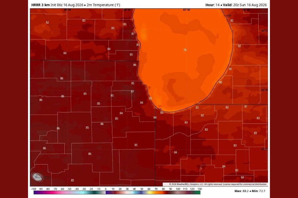
HRRR Model Shows Afternoon Highs Climbing Into the Upper 80s
The HRRR model shows afternoon temperatures peaking in the mid to upper 80s across much of the Chicago metro area, with widespread readings between 84 and 87 degrees inland from Lake Michigan.
Areas closer to the lakeshore are running slightly cooler, with temperatures in the upper 70s and low 80s near the immediate shoreline as lake-modified air keeps those readings in check.
Drier Air and Reduced Wildfire Smoke Expected by Tonight and Tomorrow
A front moving through tonight is expected to usher in noticeably drier air across Chicagoland, bringing a drop in dew points that should make conditions feel more comfortable by tomorrow. Wildfire smoke that has been lingering in the region is also backing off.
Plenty of sunshine is expected to accompany the drier air, offering a clear improvement over the cloudier, smokier conditions the region has dealt with recently.
Next Storm Chance Arrives Tuesday Night, With Cooler Air Following
The next chance for storms is not expected until Tuesday night, though forecasters say they are not seeing anything significant in the data at this time. A stronger shot of drier and cooler air is expected to arrive Wednesday through Friday.
Highs during that stretch are expected to run only in the 70s, with lows dropping into the 50s away from the lake and city, offering a notable break from recent heat before temperatures rise again in the long range.
Stay with The Main Street Journal for the latest weather updates and local forecast coverage.