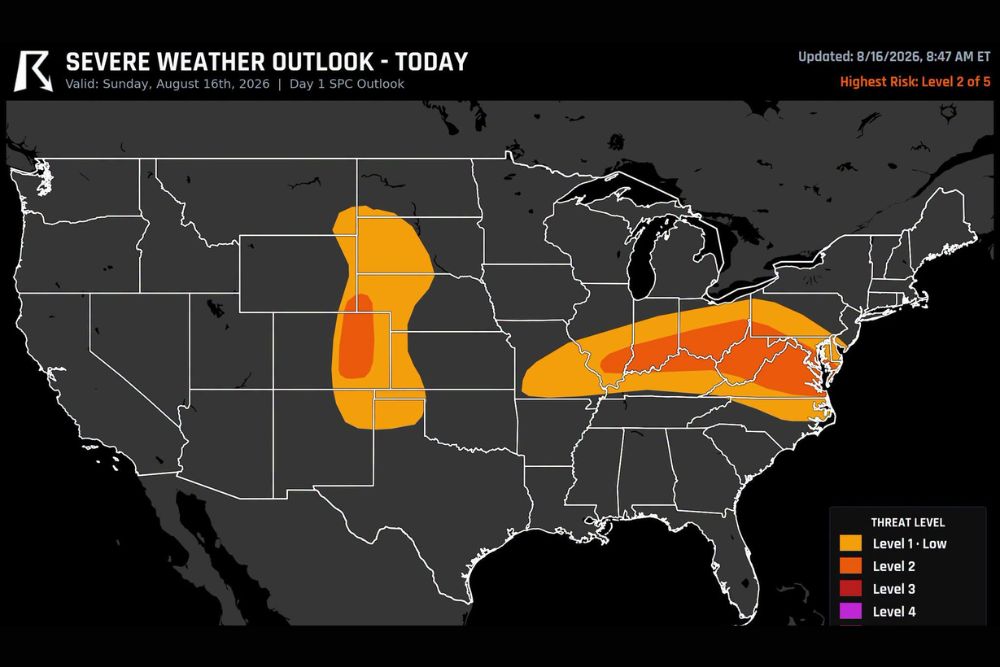
VIRGINIA — A Level 2 severe weather risk is targeting parts of Virginia, Colorado, and West Virginia Sunday, with damaging wind gusts standing out as the primary hazard for roughly 24 million people across the outlook zone. A storm cluster currently tracking across the Ohio Valley is expected to push eastward into West Virginia and Virginia by this evening while maintaining enough strength to produce damaging gusts on arrival.
Northern Virginia holds the best chance of a brief tornado today, as southerly wind shifts could provide storms just enough additional spin to get one going. Separately, storms near Colorado Springs are expected to bring large hail this afternoon.
Ohio Valley Storm Cluster Pushes Into Virginia and West Virginia by Evening
The storm complex responsible for today’s threat has been tracking across the Ohio Valley through the morning hours and is forecast to shift eastward as the day progresses. By this evening, the cluster is expected to reach West Virginia and Virginia while retaining enough intensity to generate damaging wind gusts.
Those gusts are the dominant concern within the Level 2 risk area, with forecasters warning they could affect a broad swath of the mid-Atlantic and Ohio Valley region as the system moves through during the evening hours.
Northern Virginia Carries the Best Chance for a Brief Tornado Today
Northern Virginia stands out as the area with the highest tornado potential within today’s outlook. Southerly winds shifting into the region could supply storms with just enough additional spin to produce a brief tornado as the line moves through.
While the tornado threat is not widespread, forecasters note that any storm capable of gaining rotation in this setup could quickly become the primary hazard for communities in its path during the evening hours.
Colorado Springs Storms Bring Separate Large Hail Threat This Afternoon
A separate batch of storms developing near Colorado Springs is expected to bring a large hail threat to the region this afternoon. The best window for hail-producing storms runs from 2 PM to 8 PM, with the peak chance arriving around 4 PM.
This activity is unrelated to the Ohio Valley storm cluster and reflects a distinct threat area within today’s broader Level 2 outlook, which spans roughly 24 million people across the affected zone.
Stay with The Main Street Journal for the latest weather updates and local forecast coverage.