NORTHERN OHIO — Confidence is growing that a window of storm development will move through northern Ohio this afternoon as a frontal boundary sweeps across the region. That boundary could help organize activity into a broken squall line, though not every location will see the same level of impact. Models are not showing one uniform, well-organized line, meaning some areas may see very little while others could get hit hard. The severe weather window runs from 11 AM to 7 PM if storms fully develop.
Damaging Winds and Isolated Tornado Threat Possible Where Storms Organize
Areas that do get hit could see strong to damaging wind gusts between 50 and 70 mph, along with frequent lightning as storms move through. A brief tornado or two cannot be ruled out in the strongest cells, along with isolated hail.
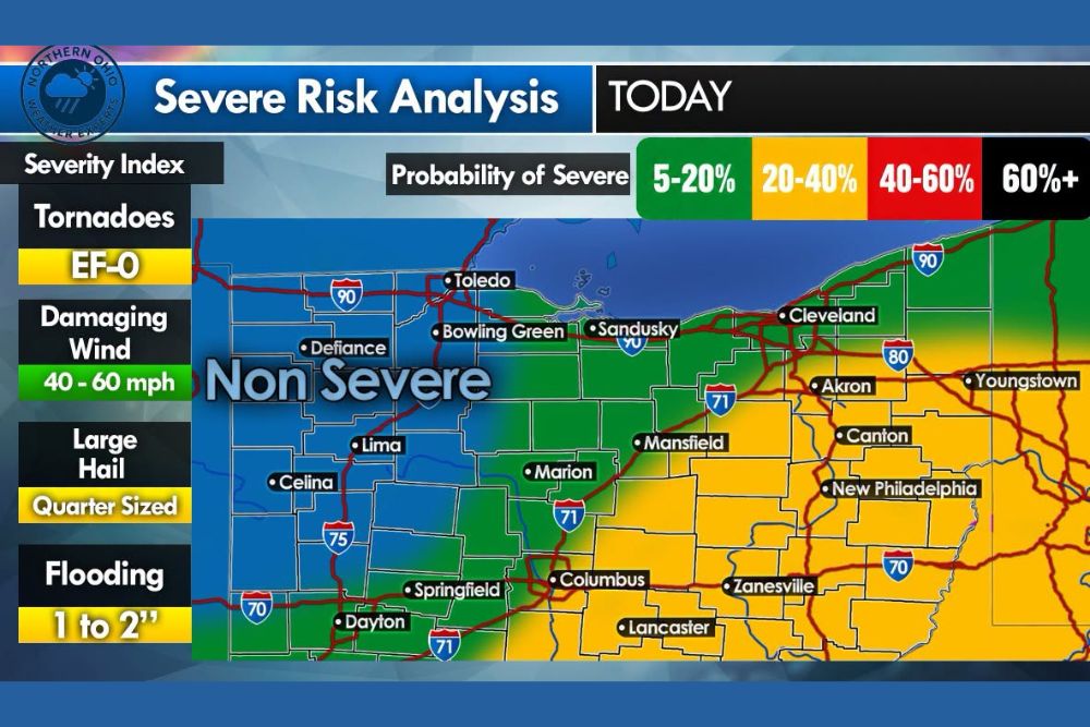
The Severe Risk Analysis places damaging wind potential at 40 to 60 mph across the outlook area, with any tornado activity expected to stay at EF-0 intensity and hail generally holding to quarter size.
Weaker Cap Today Supports Better Storm Coverage Than Previous Outlook
Forecasters have been watching the strength of the atmospheric cap over the past day, and confidence is increasing that it will be weaker today. A weaker cap supports better storm coverage and raises the chance that storms will actually break through and organize into more coherent activity.
This is an improvement from the prior day’s discussion, when the cap was seen as a bigger obstacle to storm development across the region.
Fast-Moving Storms Expected to Clear Quickly Once They Arrive
Any storms that do develop are expected to be quick-hitting, moving through a given location in about 30 minutes once they arrive. Localized flooding of 1 to 2 inches is also possible with the heaviest cells.
Southern and eastern parts of the outlook area, including Columbus, Zanesville, Lancaster, and Dayton, fall into the highest probability zone for severe weather today, while areas farther north near Toledo and Cleveland carry a lower, non-severe designation.
Stay with The Main Street Journal for the latest weather updates and local forecast coverage.